Self-Guided Hike: Geology

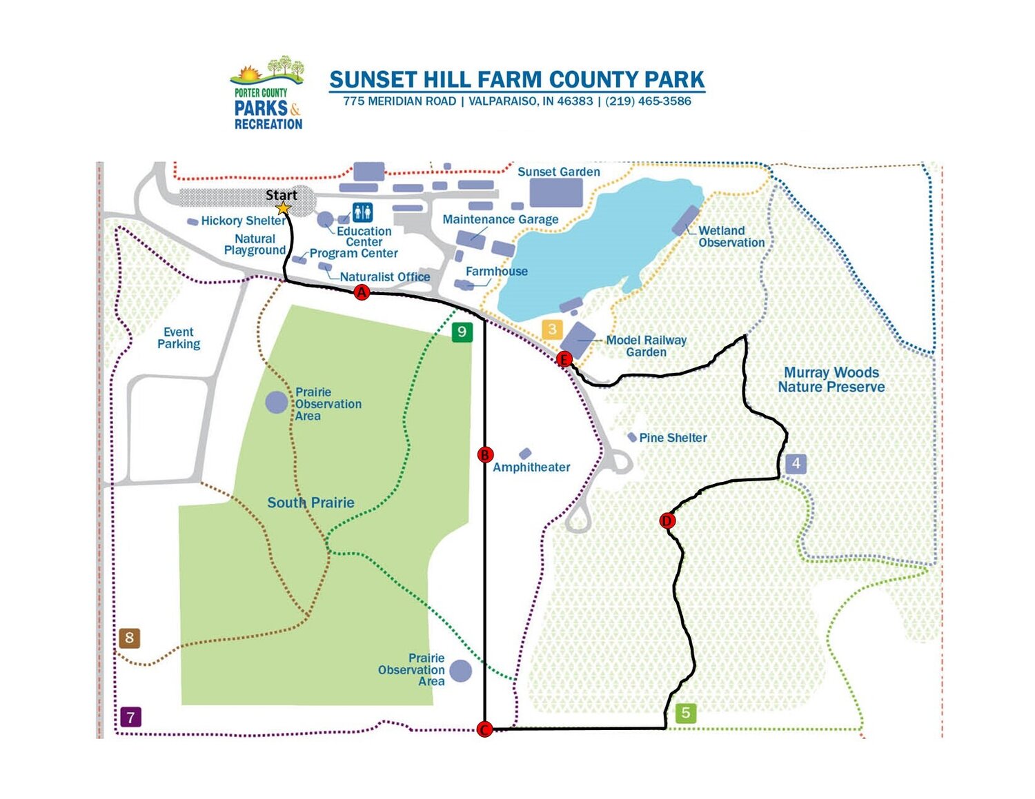
Curious about local geology? This hike is all about the geology of Sunset Hill Farm and Northwest Indiana. Check out this awesome map (at the end of this article) that Autumn, a staff Naturalist & Educator, created for you! You can also find printed copies of these hikes at the kiosk right off the main parking lot at Sunset Hill Farm.
Follow the instructions outlined below, go at your own pace, and have fun! To get started on your hike, use the map on the other side of this sheet to follow the trail. When you reach one of the stops, read the corresponding passage to learn about our park’s geology.
Stop A: A History of Rocks – Prairie
Today you’ll learn about the geology of Indiana, more specifically the geology of Sunset Hill Farm. Whenever we discuss an unfamiliar topic like geology, it’s always important to start at the beginning, In this case, that’s the rock cycle. There are 3 different types of rocks: sedimentary, igneous, and metamorphic. Sedimentary rocks like sandstone and limestone form as layers of debris (or sediment) are built up, compacted, and cemented together under the weight of the layers above them. This happens most often on the bottom of oceans, lakes, and rivers. Our second type, igneous rock, forms when molten magma cools and solidifies either above or below the Earth’s surface. Common igneous rocks include granite and obsidian. Metamorphic rocks are formed when igneous or sedimentary rocks have been structurally changed (metamorphosed) by heat, pressure, chemical processes, or a combination of the three. Well-known metamorphic rocks include marble and slate.
An important aspect of Indiana’s geology is bedrock: the solid, unweathered sheet of rock that lies beneath the surface layers of soil and sand. The bedrock of Indiana extends throughout the entire state and is nestled about 350 ft. below your feet. We don’t have any exposed bedrock in northwest Indiana, but the thick layer of topsoil above it was deposited by glaciers during the Ice Age. Primarily made of sedimentary rock (limestone, dolostone, sandstone, and shale), the bedrock in Indiana was deposited about 440-320 million years ago.
Stop B: Born from the Ice Age – Amphitheater
The primary architects of Indiana’s geology were the ice ages. The Earth went through several periods of freezing and warming, alternating between ice ages and major greenhouse events. During the ice ages, glaciers formed as piles of snow were layered on top of each other, compacted into solid ice under its own weight, and flowed southward. The glacier that carved out Indiana came from Michigan over 700,000 years ago. The land formations that you see here at Sunset Hill were also formed by this glacier. It created the massive hill in front of you that lies beneath our forest.
Stop C: What’s a Moraine? – Roller Coaster Hill
A moraine is a ridge or hill that formed on the edge of a glacier as the ice melted and sediment was deposited. Glacial sediment consisted of sand, gravel, clay, and rocks. The hill you see now, called Roller Coaster Hill, was either formed as a moraine or was carved out as meltwater ran between the glacier and a moraine. The Pines ski hill was formed in the same way. The largest and highest moraine in the area is Valparaiso Moraine, which runs parallel to Lake Michigan and occupies more than half of the land in Porter County.
Many of the lakes and streams that we have here in Northwest Indiana were also formed by glaciers. Coffee Creek and Salt Creek were both formed as meltwater carved large channels into the ground. Flint Lake is a kettle lake that formed when a massive chunk of ice broke off from a glacier, was buried by sediment, and melted. This formed a massive hole in the ground which was then filled with water.
Stop D: Sand and the Lake – Woods
As you’ve probably noticed, the soil and trails on our hill contain a lot of sand. This sand is glacial outwash: sediment that was transported and deposited as the glacial ice melted. This same glacial outwash is what formed our beloved dunes in Indiana Dunes National Park. Lake Michigan was formed about 11,000 years ago when the Wisconsin glacier melted. Different moraines in the area, like Valparaiso Moraine, formed a dam and contained the water in what is now Lake Michigan.
5,500 years ago, the water level of Lake Michigan stood 23 ft. higher than it does today. The cities of Gary, East Chicago, Miller, Ogden Dunes, Dune Acres, Beverly Shores, and the northern parts of Michigan City and Hammond would have all been under water. Over time, the water line has receded as much as 8 miles in some places, leaving its old beaches to be colonized by plants and converted into diverse forests. The remnants of the lake’s historic coastlines can still be seen today in Chesterton, Calumet Dunes, and Glenwood Dunes.
Stop E: Conclusion – Model Railway Garden
We don’t think about it much, but the way the earth has been shaped around us impacts us every single day. The Ice Age occurred so long ago, but we can still see its powerful effects every time we walk outside our front door. The geologic forces that have shaped the area we live in provides the resources we use every day, from the roads you drive on to the very food you eat. We hope that this experience has helped you learn about our area’s unique geological history and appreciate the beauty of our park.
Thank you so much for participating in our new self-guided hike! We always have events going on at our park. Visit Porter County Parks & Recreation’s Facebook page for details and updates on all your favorite programs. Do you want to take part in the wildlife conservation work we do here? Download the app iNaturalist to record all of the different plant and animal species that you find in our park. Thank you and we look forward to seeing you here again soon!